
North Quabbin Regional Landscape Partnership
The North Quabbin Regional Landscape Partnership (NQRLP) is a voluntary association of public and private groups focused on conserving land and our rural lifestyle.
The North Quabbin Regional Landscape Partnership (NQRLP) is a regional conservation partnership (RCP). RCPs are multi-stakeholder collaboratives involving land trusts, conservation organizations, academic institutions, public agencies and landowners who work across geographic and political boundaries to increase the pace and scale of land conservation and stewardship. Convened by Mount Grace, Harvard Forest, and the MA Dept. of Conservation & Recreation in 1997, the NQRLP serves the entirety of Mount Grace’s region, as well as the towns of Pelham, Shutesbury, and Leverett.
The NQRLP has four primary focus areas:
- landowner outreach
- municipal capacity-building
- landscape-scale conservation projects
- strategic mapping
Landowner Outreach

Landowner outreach has been the bread-and-butter of the NQRLP’s work for more than twenty years. The majority of land in Massachusetts is privately owned, and our conservation work is only made possible by willing landowners. For the past eleven years, we have partnered with UMass Amherst to reach as many landowners as we can to provide the most up-to-date information about conservation and stewardship options. When a landowner is ready to decide about the future of their land, we want them to have all the resources needed to make an informed decision that works for them, their family, and their land.
We’ve collaborated with land trusts and municipalities to host dozens of landowner workshops, and we’ve helped create and distribute landowner guides including “Protecting Your Legacy” to thousands of landowners across the state. This work is funded through the Massachusetts Working Forest Initiative.
Municipal Capacity Building

Local volunteers serving on conservation commissions, agricultural commissions, open space committees, and other town boards have been critical members of the NQRLP since 1997.
Every conservation restriction must be approved by the local Select Board, and municipalities are often eligible for land protection grants that land trusts are not. Our ability to conserve special places is directly enhanced by relationships with municipalities, and our local partners offer critical information about what their communities care about. This helps ensure that even our large, multi-landowner, multi-partner projects are still reflective of the needs and character of our rural communities.
The NQRLP invests directly in the capacity-building of local partners, most significantly through organizing five statewide Open Space Conferences since 2010. These conferences aim to bring municipal open space committee members (and all other interested parties) together for a day of peer-to-peer learning.
Landscape Scale Conservation
Mount Grace’s largest multi-landowner and multi-partner conservation projects were implemented through the NQRLP. The NQRLP has been particularly effective in securing federal funds for conservation through the Forest Legacy Program of the U.S. Forest Service, which is designed to protect threatened woodlands. The 22-mile Tully Trail was the first collaborative project of the NQRLP. Most recently, the NQRLP finished the Quabbin to Wachusett (Q2W) project with dozens of municipal, state, and land trust partners and nearly 40 individual woodland landowners (PDF). The project was awarded $7 million and ranked second in the country – the highest-ranked project yet to come out of Massachusetts.
The ability to organize large, complex projects like Q2W is rooted in our relationships with partners and our expertise in organizing effective landowner outreach programs. Collaboration is our greatest strength and the key to increasing the pace and scale of land conservation.
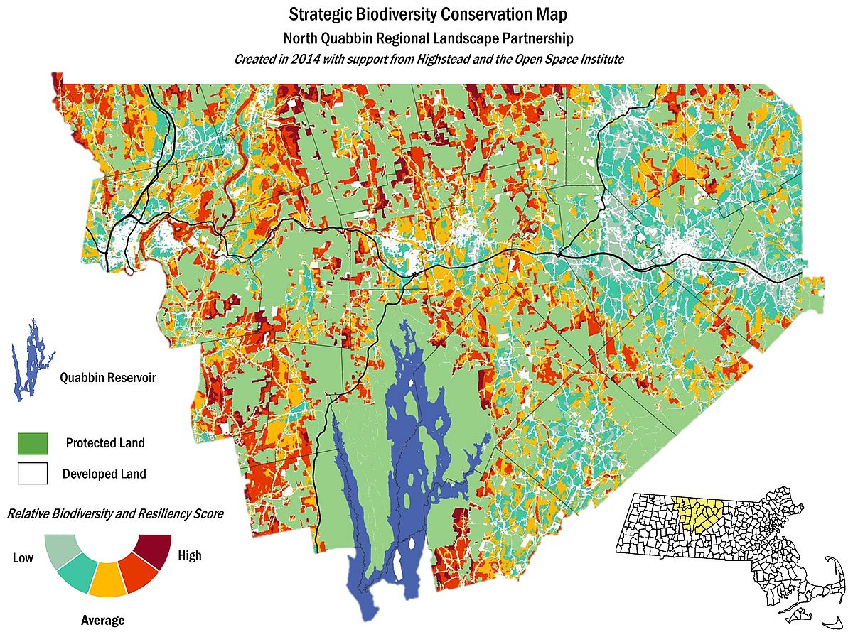
Strategic Mapping
In 2014, the NQRLP received a grant from the Open Space Institute and the Highstead Foundation to create a climate change-informed strategic map. We were tasked with utilizing the brand-new climate resilience data created by The Nature Conservancy and translating it into a tool that we – as on-the-ground practitioners – could readily use. Over the course of several busy months, we created a map that combined existing statewide data already prioritized by state funding sources with the newest climate change data. The resulting map showed us the areas that were mostly likely to retain their biodiversity in the face of climate change. In 2016, our work was profiled in “Conserving Nature in a Changing Climate: A Three-Part Guide for Land Trusts in the Northeast.”
Map download

Strategic Biodiversity Conservation Map
File size: 709 KB
If interested in learning more about the North Quabbin Regional Landscape Partnership, please contact Conservation Director Sarah Wells at 978-541-1773 or wells@mountgrace.org.