On the Trails: Hidden Valley Memorial Forest
By David Kotker
On the internet, opinions on Lynne’s Falls can be starkly divided. Some hikers find the falls, located near the boundary of Mount Grace’s Hidden Valley Conservation Area in Wendell, to be beautiful, others are less impressed. A more careful reading of people’s timestamped comments reveals a pattern. The underwhelmed have mostly visited in the summer or during a dry autumn; excellent seasons for hiking, but poorly timed for this particular hike, because Lynne’s Falls, like several of the waterfalls on Mount Grace hikes, is seasonal.
Also contributing to the confusion, the unnamed brooklet that flows through Hidden Valley on its way to Lyon’s Brook forms two different cascades about 500 feet apart. Lynne’s Falls is upstream, and is the larger of the two, but both are worth a visit in season.
Hidden Valley was named by Arthur Cronquist, an internationally renowned botanist who used the 67-acre site for research and recreation. The land was donated to Mount Grace by Mabel Cronquist in 1996. Mabel and Arthur also named the falls in honor of their daughter Elizabeth Lynne Cronquist.
Hidden Valley is surrounded on three sides by the Wendell State Forest. To the west it is bordered by privately held conservation land, making it an inholding in a vast swath of protected forest. It can be discovered via the New England National Scenic Trail (former known as the Metacomet Monadnock Trail), which is marked by white rectangular blazes and is easy to find at the north end of the Wendell State Forest parking area next to Ruggles Pond.


Lyons Brook heads north from Ruggles Pond on its way to the Millers River. The trail almost immediately passes an open-faced public shelter (complete with fire pit) for distance hikers and then descends northwards keeping the brook on its left and traversing several tiny freshets and seasonal streams via rustic hiking bridges or stepping stones.
Suddenly, the open forest becomes a thicket of mountain laurel, encroaching on the now narrow trail from every side. Amid the laurel are the blown down remains of trees lost to the microburst tornado that ripped through this area in 2006. Passing the tornado’s footprint, you are soon back in mature forest, with Lyons Brook now becoming visible (it’s been audible for a while) at the bottom of a small gorge on your left.
As you approach the junction of Lyons Brook and its unnamed tributary, the trail turns to the right. This is the lowest point of your journey and you will now ascend alongside the first cascade, with the water pouring down 30 or so feet of rocky precipice on your left. Once you’ve followed the trail across the brook on another rustic bridge you are officially in Hidden Valley. Mount Grace signs will welcome you here and are posted at the main trail intersections.

The New England Scenic Trail continues north for about ¼ mile before making a switchback to traverse the cliffy ascent that will bring it to Jerusalem Road, one of the many woods roads winding through the state forest. These rocky cliffs and ledges provide a variety of denning sites for bobcats and other creatures, as well as hosting hemlocks and oaks of exceptional size which were spared from past timber harvest by the difficult terrain. At the cliffside you will see a plaque memorializing the Cronquists’ donation of the property, and if you wish you can follow the woods roads south back to Ruggles Pond.
Alternatively, you could bear left at the switchback to take the Hidden Valley Loop Trail (blue diamonds replace the New England Trail’s white rectangles for this one). The loop takes you past signs of past colonial or early 18th century use including stone walls on either side and an old foundation on your left (we’re going counterclockwise along the loop) before heading south to return to the NEST south of the switchback.
If you’re ambitious, you could instead continue north from the apex of the loop to leave Hidden Valley and ascend the summit of Jerusalem Hill, which offers a view across the Millers River Valley. Up and back to the overlook adds about ½ mile to your total hike.
Once you are returning south along the New England Scenic Trail, the spur trail to Lynne’s Falls will be on your left. It’s a short walk through those oaks and hemlocks to this one. Bigger than its sister downstream, the water drops down the steep hillside taking a series of hops and jumps and then, as the slope lessens, splitting and recombining across a small wetland as it heads on to its next cascade. Returning up the spur trail you will turn left at the main stem and retrace your steps south past the lower falls, Lyons Brook, the mountain laurel, and the hikers’ shelter to return to Ruggles Pond.
About 2.5 miles out and back from Ruggles lot. A little more if you go to Jerusalem Hill.
About 200 feet of total altitude change (but keep in mind it’s down, up, around, down again, and up again—so you actually climb the 200’ twice).
Fairly easy.
Best done when the water is high and the ice is off the trail. Early May is probably good. I went during December thaw. Still a bit slippery.
Parking at the Ruggles Pond lot is $8 in season for Massachusetts residents; you can also park at the roadside and hike in if the gate is closed for winter.
David Kotker is a longtime Wendell resident, Development Director at Mount Grace, and avid hiker.
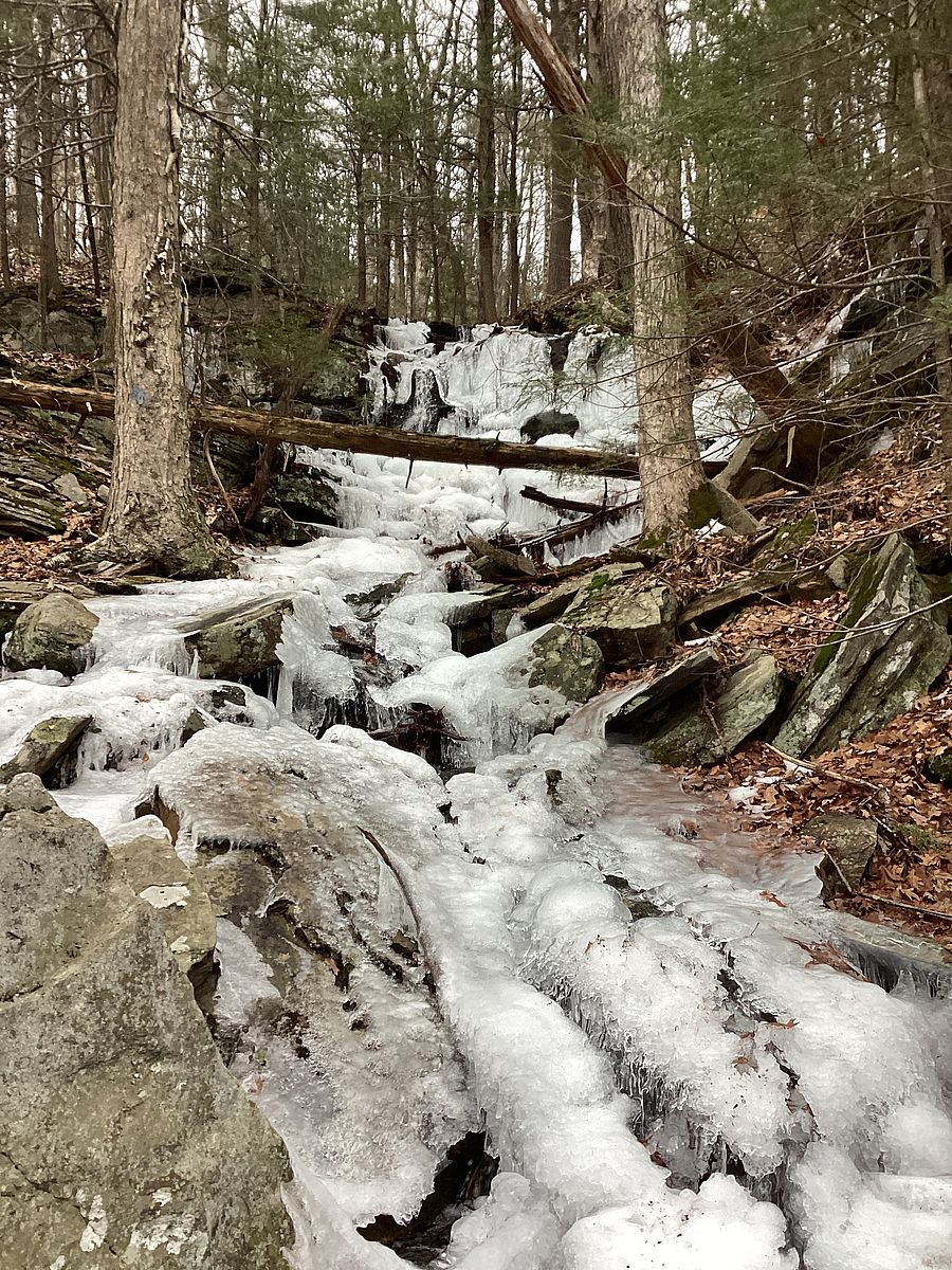
An icy Lynne Falls